GCRA
OVERVIEW
FAQ
NEWS
ARTICLES
PHOTOS
REEF ISSUES
RESTORATION
PAPERS
LINKS
|
|
|
|
Water Quality in Ashton Harbour, Union Island, St. Vincent & the Grenadines: Environmental Impacts of Marina and Recommendations for Ecosystem and Fisheries Restoration Thomas J. Goreau & Nicholas Sammons July 14, 2003 TO: The Hon. Ralph Gonsalves, Prime Minister The Hon. Dr. Douglas Slater, Minister of Health and Environment The Hon. Girlyn McGill, Minister of Agriculture and Fisheries The Hon. Rene Baptiste, Minister of Tourism Reynold Murray, Environmental Services Coordinator, MHE Mr. Philmore Isaacs, Chief Agricultural Officer, MAF Ms. Pamela Browne, Permanent Secretary, MAF Senator Snagg, Representative from Union Island Member of Parliament Oliviere, Representative from Union Island The Union Island Association for Ecological Protection Union Island Ecotourism Movement Union Island Fishermen's Cooperatives And the people of Union Island SUMMARY
In order to assess the environmental impact
of the Ashton Marina Project, corals and algae were examined, and 273 water
quality measurements were made at sites in and around Ashton Harbor,
Union Island. Blockage of natural water circulation in the harbor by the
causeway has resulted in waters in the western half being very significantly
higher in temperature and salinity and lower in oxygen than the eastern half.
Coral reefs, seagrasses, lobsters, conch, and fishes have already largely
disappeared. If the Marina were to be completed, inputs of petroleum
hydrocarbons, sewage nutrients, and oxygen-consuming wastes would turn the
western harbor into an oxygen-deficient, polluted, and foul smelling pond.
Action is needed promptly to reverse the damage to reefs, seagrasses, and
fisheries caused by blocked circulation. A community-based strategy is outlined
for restoration of the lagoon and its natural flushing rate, by removing the
causeway and fingers, to reestablish the coral reefs, seagrasses, and fisheries. BACKGROUND Ashton Harbour is the largest bay on Union Island, and had the greatest range of environmental habitats. They included the largest mangroves in the Grenadines, seagrass beds rich in lobster and lambi (conch), coral reefs of fringing, patch, and barrier reef types, and an offshore island (Frigate) that was an important bird habitat (W. S. Price. & P. G. Price, 1994, A survey of the nearshore marine environment of Union Island, St. Vincent & the Grenadines, Union Island Association for Ecological Protection(UIEP)). Because of its environmental importance, Ashton Harbour was selected to be a Conservation Area under Schedule 11, Regulation 20, The Fisheries Act, 1986, and was formally designated as such on January 5th, 1987 (W. S. Price. & P. G. Price, 1994, Ashton Marina project, potential ecological impact on Union Island, St. Vincent & the Grenadines, Union Island Association for Ecological Protection). However no management was ever implemented. Despite this official designation as a protected area, a 300 boat marina project was proposed for the lagoon by developers. An environmental impact study of the proposed project was carried out before its implementation. This pointed out that if the development were to be carried out, the causeways would cut off water circulation to the bay, causing catastrophic damage to reefs, seagrasses, and fisheries (W. S. Price. & P. G. Price, 1994, Ashton Marina project, potential ecological impact on Union Island, St. Vincent & the Grenadines, Union Island Association for Ecological Protection). Although many citizens of the fishing village of Ashton, a community with very high unemployment, were attracted by claims that local jobs and economic benefits would follow, many local residents opposed the project on grounds that it would cause irreparable environmental and social harm to their community (M. Harvey, 1991, A 17 point article on the social, cultural, and economical disadvantage of the Ashton Marina complex, Union Island Ecotourism Movement). Although the developers presented no environmental impact assessment in support of this project in a Conservation Area, the project proceeded, with exactly the results that had been predicted. After dredging and bisecting causeways that blocked circulation of water through the bay, the "developers" vanished and the project was abandoned. However, to add insult to the monstrous environmental damage, they managed to steal a large loan negotiated from European sources, which they tricked the St. Vincent Government into guaranteeing financially. Although the project collapsed, preventing further pollution of the bay by marine fuels, boat sewage and wastes, the causeway's blockage of the bay's circulation caused the western half of the bay to become stagnant, and the water turbid. This killed coral reefs, seagrasses, lobster, fish, and lambi in this half of the bay. At the same time, blockage of circulation caused sand to accumulate in the eastern half of the bay, smothering coral reefs and seagrasses, and wiping out the local fish, lobster, and lambi populations as well. It must be remembered, that this lagoon system may be a critically important source of juvenile recruits to very important commercial fisheries throughout the Grenadines, especially conch, lobster, and snappers. The resources of the largest fishing community on the island have been destroyed, without compensation (W. S. Price & P. G. Price, 1997, Paradise lost: Post mortem of the Ashton Marina project ecological impact on Ashton Lagoon, Union Island, St. Vincent & the Grenadines, Union Island Association for Ecological Protection.). ECOLOGICAL SURVEY RESULTS Assessment of the health of coral reefs all around Union Island and at nearby islands including Mayreau, Petit Saint Vincent, Palm Island, and the Tobago Keys, was carried out by Global Coral Reef Alliance reef health assessment experts during February 2003. These included filming and identifying the health of all coral and algae species, and extensive discussions with local fishermen, divers, environmentalists, and hotel personnel concerning long term changes in the coral reefs of these islands. The western half of Aston Harbour was found to be stagnant, and the water was green with chlorophyll due to excessive nutrient buildup, causing turbidity that blocked light needed for seagrasses, corals, and fisheries. The mangroves had been severely stunted in most of their area due to interference with natural seawater circulation caused by the construction of causeways. Reefs on the western side of Frigate Island were in poor condition with low live coral cover. Corals inside the lagoon in the eastern side of the bay were mostly dead and overgrown with weedy algae, as the result of nutrient buildup due to poor circulation. No lobster or conch were seen anywhere, although these had formerly been extremely abundant according to local fishermen. Only the outer reef barrier reef slope was free of weedy algae. Despite lack of pollution, the corals of the fore-reef area were not in good condition, with far more dead than living coral. The reef crest had formerly been composed of massive growths of elkhorn coral (Acropora palmata) but these were almost all dead. It is certain that these shallow reefs were killed by the White Band coral disease epidemic that destroyed this species throughout the Caribbean around 1980, and there has been only very minor recovery since then. Although there were a few small patches of young live elkhorn coral, these made up no more than a few percent of the abundance of the standing dead elkhorn coral. These reefs were in excellent condition in the mid 1970s, when they were regarded as the best reefs in the Grenadines (W.H. Adey, P. J. Adey, R. Burke, and L. S. Kaufman, Holocene refs of the Eastern Caribbean, 1977, Atoll Research Bulletin, 218:1-40). The predominant live corals seen in shallow water are weedy species of Porites astreoides, Porites divaricata, and of fire corals, Millepora squarrosa, Millepora complanata, and Millepora alcicornis. These species quickly overgrow dead reef framework but do not themselves build it. Many head corals were found to have suffered mortality on their tops around five years ago, based on the amount of growth of the surviving sides, almost certainly as the result of the moderately severe 1998 regional coral bleaching event caused by global warming. The deeper reef is almost entirely dominated by large colonies of star corals, (Montastrea annularis). However about half of the surfaces of these corals were dead, and active signs of Black Band Disease, Yellow Band Disease, Dark Spot Disease, and Rapid Wasting Disease were seen on them. No young corals of this species were seen. All small colonies seen were clearly surviving portions of larger colonies with no new recruits. So, although this species is dominant in the deeper reef, it appears to have suffered complete reproductive failure, and young corals are not replacing those that are dying from diseases. It appeared that large amounts of this coral had been infected by fungi and attacked by parrotfish, probably during 1997, when a similar infection was recorded in Bonaire and other sites around the Caribbean (T. J. Goreau, J. Cervino, M. Goreau, R. Hayes, M. Hayes, L. Richardson, G. Smith, K. DeMeyer, I. Nagelkerken, J. Garzon-Ferrera, D. Gil, G. Garrison, E. H. Williams, L. Bunkley-Williams, C. Quirolo, K. Patterson, J. Porter, & K. Porter, 1998, Rapid spread of diseases in Caribbean coral reefs, REVISTA BIOLOGIA TROPICAL 46 Supl. 5: 157-171). The effects here appear to have been about as severe as in Bonaire, formerly regarded as the worst known area affected in the Caribbean. So intensive were the effects that many star coral heads in the Ashton fore reef were observed to have had their tops destroyed to the point that they were concave rather than convex! WATER QUALITY SURVEY RESULTSThe 273 measurements of water quality (temperature, salinity, and oxygen) were made in and around Ashton Harbour (Results: Appendix 1, Statistics: Appendix 2, Map: Appendix 3)). Measurements were made in all marine habitats of both eastern and western Ashton Harbour and in offshore waters in front of them. Measurements included 10 distinct habitats: A) inner west harbour in front of mangroves, B) inner west harbour in front of town, C) green water between causeways, west harbour, D) outer west harbour in front of Frigate Island, E) outer east harbour in front of Frigate Island, F) inner east harbour in front of mangroves, G) inner east harbour seagrasses and reef in front of rocky shore, H) east harbour fore reef ocean side, I) outer east harbour seagrasses and reef flat, J) outer west harbour seagrasses and reef flat. Measurements were made at the surface, and every five feet in depth as far as could be done to 20 feet. Statistical analysis of the data showed very strongly significant patterns: 1) western areas had higher temperature than eastern areas 2) there was no significant variation of temperature with depth 3) western areas had higher salinity than eastern areas 4) there was no significant variation of salinity with depth 5) western areas had lower oxygen than eastern areas 6) deeper western waters had lower oxygen than surface waters 7) there was no significant variation of oxygen with depth in eastern waters. 8) very high oxygen levels were produced by the seagrasses in the eastern harbour, but there was little surviving seagrass in the western harbour. Most of these correlations were very strong statistically (appendix 2) and had less than a 1% probability of being due to chance. The weakest correlation’s had no more than a 3% probability of being due to chance, (i.e., they have a confidence level of at least 97%). Ashton Harbour formerly was extremely well mixed by strong east to west currents that carried clean ocean water, rich in oxygen, straight across the harbour. The causeway has completely blocked this circulation, so that the western harbor is very poorly mixed, and sediment piles up in the eastern harbor. Blockage of the natural circulation has caused stagnation in the western harbour, causing higher temperatures due to solar radiation. Blockage also creates a much longer residence time of the water in shallow areas adding to the increase in heat and salinity. While eastern areas have very high levels of oxygen, largely produced by seagrasses, western areas have significantly lower levels of oxygen. The deepest western areas have even lower levels that are exacerbated by removal of oxygen by decomposition of organic matter in stagnant deeper sediments. No source of freshwater to the bay was found either from the mangroves or from the mainland and town. In contrast, no stagnation was found in deeper waters in eastern Ashton Harbour because of the increased flushing rates and stronger currents. These changes have resulted purely from physical blockage of circulation by the causeways and ship fingers, because the collapse of the project has prevented any additional inputs of leaking petroleum hydrocarbons, release of sewage, and dumping of organic wastes from boats and land facilities. Had the Marina project gone through, these sources of pollution into the shallow stagnant bay would have caused oxygen to be consumed in deeper water. This would have resulted in death of all organisms except bacteria in bottom water, turbid green surface water, and release of hydrogen sulfide from oxygen deficient waters and sediments, making the area stink with the rotten egg smell of sulphur, plus oil, gas, and sewage. RECOMMENDATIONS Catastrophic damage has been done to Ashton Harbour by a failed marine development that should never have been allowed to take place in a legally-protected Conservation Area. Although barely started, the first phase of development impacted the environment the most. The coral reefs have been devastated, as well as the seagrasses, the fish, lobster, and conch (lambi) resources of the largest fishing village on the island. This has greatly increasing economic hardship and unemployment of residents. An active program of marine environmental restoration is urgently needed. The following provides a brief outline towards possible restoration strategies. There is no doubt that the only mitigation for this disaster is to remove the causeways and reopen circulation to the bay (W. S. Price & P. G. Price, 1997, Paradise lost: Post mortem of the Ashton Marina project ecological impact on Ashton Lagoon, Union Island, St. Vincent & the Grenadines, Union Island Association for Ecological Protection.). A proposal to do so has been submitted to the European Union by the Union Island Association for Ecological Protection and the Union Island Ecotourism Movement, and approved for funding by the EU, but implementation has foundered over the issue of control of the land involved (Jacques Daudin and Matthew Harvey, personal communication, 2003). Apparently the failed project is in receivership by the bank, which still hopes a developer will come in with money to complete the project. This would greatly worsen the ecological damage. Nearby Clifton Harbor already has adequate deep water boat anchorage’s and shore facilities, the proposed marina is not needed and not financially viable, especially in the currently depressed tourism economy. We suggest that the Government endorse the restoration of Ashton Lagoon and work through the local NGO”s and return the “land” used for the causeway be removed. In addition we should turn over the lands (causeway) in question, to the local non-profit organizations to manage the designated protected area, so that they can receive the European Union funds allocated for the Lagoon restoration. . Active restoration and community based management is essential to reverse the ecological damage to reefs and fisheries. Use of the Biorock method, which is easily taught to fishermen, is recommended to restore coral growth, reproduction, resistance to environmental stress, and to create habitat to restore fish and lobster populations (www.globalcoral.org). A conch and lobster hatchery should be established using some of the enclosures that do not block circulation of the bay. Seaweed mariculture should be established, both as a form of alternative income for fishermen, but also to increase recruitment of juvenile lobster and lambi. Studies by A. H. Macfarlane and T. Goreau found that large numbers of young lambi and lobster, as well as fish, were attracted to algal mariculture projects in Jamaica, helping increase their populations in nearby seagrasses and reefs (A. H. Macfarlane, M. Sc. Thesis, University of Miami, Effects of nutrients, herbivory, and epiphytes on the growth, nutrient uptake, and elemental composition of Gracilaria grown in mariculture). These methods should be applied to Ashton Bay to increase lobster and conch reproduction, recruitment, and densities at all phases of their life cycles. An economically important seaweed, (Gracillarius dominiguensis) was once common in the bay and can be grown, but is now absent, but again it too needs clear water with a current. It is also recommended that a survey be made of the physical circulation patterns in the bay under various scenarios of re-opening circulation in order to determine the most environmentally appropriate, and cost-effective method of doing so. David Harris, a coastal zone engineer in Trinidad, is recommended for such a study due to his experience with computer modeling of circulation patterns based on studies of waves, currents, and bathymetry throughout the Eastern Caribbean. A marine oceanographic study of recruitment patterns is needed. Detailed discussions with fishermen found that most were extremely aware of the severe degradation that had taken place to their fisheries, and eager to participate in active steps to restore them. The Global Coral Reef Alliance is ready to assist Union Island Fishermen's Cooperatives, the Union Island Association for Ecological Protection, the Union Island Ecotourism Movement, and the Ministries of Health and Environment, Tourism, and Agriculture and Fisheries with technical help in restoring damaged coral reefs and fisheries and training local participants in design, construction, maintenance, and repair of such projects. The first step would be to establish a small pilot project to demonstrate and assess the benefits of such projects in terms of increased growth of corals and fish populations. Suitable sites were identified for projects in collaboration with Union Island Fishermen's Cooperatives and Environmental Organizations, but all efforts to implement them were blocked by bureaucrats in Kingstown based on a long series of odd and flimsily-contrived objections, coupled to denial that restoration was needed in Grenadines reefs! Unfortunately bureaucratic inertia seems to be preventing active community-based ecosystem and fisheries restoration. At present, shallow reef ecosystems in Union Island and other islands in the Grenadines are severely over fished and depleted in fisheries stocks. Fishermen are producing large yields of lambi by using SCUBA gear to fish the populations on the deep banks between the islands. Catches are still high using this gear, but the situation is unsustainable while shallow water nurseries are being damaged, and catches will eventually decline severely, as has happened in all other islands of the Caribbean except with the Turks and Caicos Islands. Those islands have set their goal as “sustainable” fisheries, and in order to control effort they agree to and strictly enforce a ban on spearguns as well as the use of SCUBA diving gear to catch lobster and conch. Fisheries restoration is needed now before this crash comes. A recent (2003) report by the Lighthouse Foundation on Sustainable Integrated Development and Biodiversity Conservation in the Grenadine Islands states that "In the Grenadines there is no integrated plan within which to pursue development and conservation. In most cases, development is taking place haphazardly and both governmental and non-governmental organizations lack the capacity to develop an integrated framework or to participate fully in its development. The purpose of the project is to develop a participatory co-management framework for integrated sustainable development and to implement those parts of the plan associated with the environment and the use of the marine resources. Another purpose is to develop a model for participatory sustainable development in small island systems that can be adapted and applied elsewhere. “Implementation of the main elements of the five-year core program,” is expected to: 1. Include substantial institutional capacity building for local NGOs and government departments; 2. Focus on the establishment of management and co-management systems required for sustainable resource use and management; and 3. Prepare proposals and seek funding for related elements that exceed the phase2 core budget and scope". (http://www.lighthouse-foundation.org/lighthouse-foundation.org/eng/projects/artikel00385eng.html) We fully concur with this important report, based on a long series of community inputs, which urges an urgently needed program of environmentally-sound development for the long-term future of the Grenadines people. We further recommend that a perfect starting point would be a commitment from the Government to undo the environmental crime that was committed in Ashton Harbour and to compensate the Ashton fishermen for the damage done to their resources. This could be best done by actively supporting the fishing community to acquire the tools needed to restore and sustainable manage Ashton Harbour. We further recommend that the no further development be permitted in Richmond Bay. The reefs north of Bigsands Hotel are the best now left on the island, based on our island-wide survey. The beach is used every day by the entire local community, as their only accessible beautiful swimming spot. This natural treasure is a priceless attraction to tourists, but only if it is kept clean and clear of further development that would ruin it the way that Ashton Harbour and Frigate Island were destroyed. Richmond Bay should be made into a national park as a public trust free from further development, and all its coral reef and mangrove ecosystems protected intact, before any further damage or encroachment takes place. ACKNOWLEDMENTS We thank all
the fishermen of Ashton and Clifton, Jacques Daudin, Matthew Harvey, Dr. Stephen
Price, Dr. Purnila Price, Prof. Les Kaufman, Dr. Karl Aiken and Dr. Robin Mahon
of the University of the West Indies, Jens Ambsdorf of the Lighthouse
Foundation, and many residents of Union Island for intensive discussions on long
term change in Union Island coral reefs and fisheries. We thank Beadworks Inc.
for a donation that covered most of the cost of this project. This report is
dedicated to the memory of the late Janet Wall of Union Island, an indefatigable
defender of the natural beauty of Union Island.
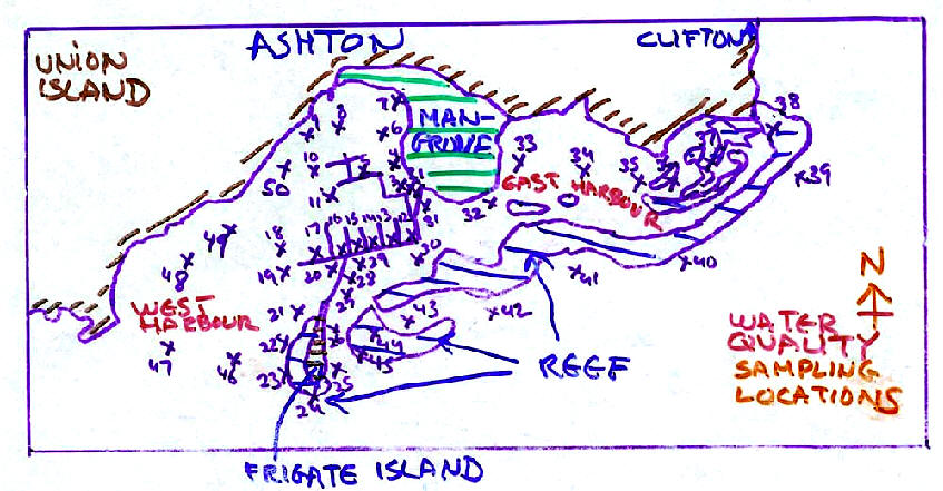
APPENDIX 1 Data showing site location numbers (map of sites available from authors upon request), depths of measurements (in feet), temperature (in degrees Celsius), salinity (in parts per thousand), and oxygen (as percentage of saturation with the atmosphere), classified by habitat type and depth.
APPENDIX 2 Probabilities (P values from T-test) that measured values of temperature, salinity, and dissolved oxygen are equal. A P value of less than 0.05 is considered statistically significant, a P value less than 0.01 is considered strongly statistically significant. P values greater than 0.05 ( that is more than one chance in 20 that it could have occurred by chance) is regarded as not statistically significant. In this analysis all sites in the western part of the bay were aggregated and compared to those from the eastern part, and all samples from 0.5 feet were regarded as surface values, and all deeper measurements regarded as deep values.
APPENDIX 3 Map of water quality sampling locations.
|
| |||||||||||||||||||||||||||||||||||||||||||||||||||||||||||||||||||||||||||||||||||||||||||||||||||||||||||||||||||||||||||||||||||||||||||||||||||||||||||||||||||||||||||||||||||||||||||||||||||||||||||||||||||||||||||||||||||||||||||||||||||||||||||||||||||||||||||||||||||||||||||||||||||||||||||||||||||||||||||||||||||||||||||||||||||||||||||||||||||||||||||||||||||||||||||||||||||||||||||||||||||||||||||||||||||||||||||||||||||||||||||||||||||||||||||||||||||||||||||||||||||||||||||||||||||||||||||||||||||||||||||||||||||||||||||||||||||||||||||||||||||||||||||||||||||||||||||||||||||||||||||||||||||||||||||||||||||||||||||||||||||||||||||||||||||||||||||||||||||||||||||||||||||||||||||||||||||||||||||||||||||||||||||||||||||||||||||||||||||||||||||||||||||||||||||||||||