|

Saya De Malha Bathymetric
Survey Report
Introduction
The Lighthouse Foundation in Hamburg, Germany, granted SUN & SEA e.V.,
Germany, funds for an exploratory expedition to Saya de Malha Bank in the Indian
Ocean, for March 2002.
The goals of this scientific
exploration were defined as performing:
• A first assessment of flora and fauna of selected areas of the bank
• The building of a coral ark
• Initial assessment of the ecological significance of the researched area
• Documentation and reports on this relatively unknown area in the Indian Ocean
The Saya de Malha Expedition
2002 commenced on March 11 and ended March 28, 2002.
Summary
The Saya de Malha Banks are one of the least known shallow marine ecosystems in
the world. As they are avoided as a potential hazard to navigation, little
mapping or scientific research had been carried there prior to this expedition.
They are dominated by
seagrasses and coral reefs, are a major whale breeding ground, and are a key
stepping stone in the migration of shallow water species across the Indian
Ocean. The bottom was found to be composed of a generally flat sloping limestone
rock covered by seagrass interspersed with small coral reefs. Drilling of the
surface showed that the bottom is made up of layered growths of red calcareous
algae, and studies are underway to determine the age and growth rate of this
material. The fauna and flora were filmed, and a visual biodiversity
encyclopedia will be prepared showing all the species found and their diversity.
Coral reefs had suffered extensive mortality between 1997 and 2002, almost
certainly due to severe high temperatures in 1998, but there were many new young
corals that had settled since then.
Because of the rich
supply of nutrients and plankton delivered to the banks from adjacent deep
waters, the Banks are an oasis of high productivity. Since a large part of the
seagrass organic production is swept by the currents into deep waters, where
some of it is buried in deep sediments, the banks serve as a significant sink of
atmospheric carbon dioxide and a source of oxygen. Future work is needed to map
the ecosystems on the bank and characterize their importance in maintaining
biodiversity and global geochemical balances.
Because Saya de Malha is
the largest shallow tropical marine ecosystem in the world that lies mainly in
International Waters outside of all territorial jurisdiction, they are in strong
need of protection, which will require establishment of an unprecedented
International Biosphere Reserve, the first of its kind.
Abstract
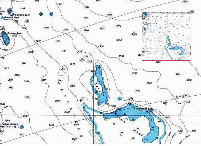
The existing sources of detailed bathymetric data for the Saya de Malha banks
are minimal. The aim of the work carried out in 2002 was to survey a 2 km2
part of the bank, map it, and if possible to identify significant changes in
depth which could represent underwater structures such as reefs. The results
show that it is possible to carry out real-time bathymetric surveys using
limited equipment and basic techniques onboard a small research vessel. The
advantage of processing at least some of the data in situ is that the survey
can be carried out in a controlled fashion and any potentially interesting
survey data can be observed and revisited for a more detailed inspection. This
is extremely important when working on a site as remote as Saya de Malha.
Although the analysis has shown that the area is largely flat, it has shown that
there may be some interesting changes in the bathymetry approximately 1km to the
north east of the main site. Any further visits to the area should attempt to
incorporate diving or underwater viewing at this location for further analysis
of the causes of these. It is also apparent that the trend of the bathymetry was
to become shallower as we moved in an easterly direction, despite the fact that
present day hydrographic charts indicate that we were located on the edge of
the bank and the depth should have been increasing. Any future visit to the site
should attempt to survey in an easterly direction to ascertain where the edge of
the bank actually is.
For the complete Saya De Malha Expedition Report,
complete with color photos and other illustrations, please click here. 2MB PDF.
|